Pages

Thursday, 17 November 2016

Four Moody Munros

Date: 15th June 2008
Those there: Me on my Jack Jones
Hills Climbed: Sgairneach Mhor, Beinn Udlamain, A' Mharconaich and Geal-Charn
Map: Explorer 393
Distance: about 11 miles (ascent 1150m)

I was staying in Scotland again at this time and got a bit of spare time so jibbed out for a walk in those there hills (more appropriately mountains really). I got a lift to the start of this hiking trail as I wanted to finish at a different point to where I started to avoid the road miles. I was staying not far from here so it was no great shakes for someone to run me out.

I got dropped off on the A9 south of Dalwhinnie in the Highlands (at 633751) and walked under the bridge heading into the hills along the track up Coire Dhomain next to the stream. Not long later I passed and greeted 2 guys who were just on their way back to the road, as it turned out they were the only people I saw all arvo which is always a pleasure. The track meanders up the Coire in the shadow of Sgairneach Mhor alongside the stream all the way. It had been quite a nice day up until this point but seemingly it looked like it could turn, anything can happen in the Highlands weather wise so I wasn't overly holding out a mountain of hope.
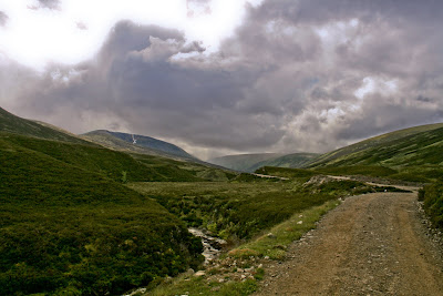
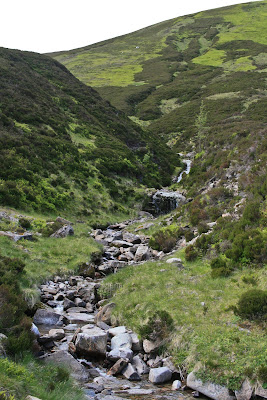
view up Coire Dhomain
Stream in Coire Dhomain
When the path comes to a bit of an abrupt end (593742) I took a turn south and trudged straight uphill next to the stream (it was more of a trickle really). As expected the sky turned a darker shade of black and whilst I donned my waterproof jacket waiting for the deluge to hit a rainbow appeared what seemed to be about 50 yards away (always hard to tell as they're pretty deceptive and I never have found that pot of gold either way though it was pretty close) but no rain followed. The sun continued to shine on the righteous, needless to say I was thoroughly in the shade.

Rainbow from the side of Sgairneach Mhor

Anyway I carried on trudging for the plateau which I reached eventually and the first thing that hit me with the view to the west was the overwhelming sight of Highland wilderness, truly incredible! So after shouting WOW a couple of times, which was to be heard by myself alone, I made the very short stroll to the top of Sgairneach Mhor. From here you get a great view up and down the Spey Valley on a good day needless to say my vista had a pretty moody feel, still no rain yet though.

Looking North up the Spey Valley
Highland Wilderness

Customarily I absorbed the view into the memory bank and then kicked off along the hiking trail to Beinn Udlamain which you can visibly see straight across the other side of the valley. For ease sake though I followed the plateau down to the saddle (578727) at a semi jog and then followed the path to the summit. It was about this point that the rain caught up with me and gave me a good dowse, causing a bit of frustration as I was sweltering and could have done with shedding a layer (not until the rain packed in though).

This is a pretty straight run and over your shoulder you start to get a pretty impressive view of Loch Ericht. Although the weather was a bit crappy. At the top i sat down and took a couple of photos looking down the loch with a fairly oppressive and moody atmosphere. Literally only a couple of minutes later though, bizarrely the cloud seemed to disperse and the rain went from a light spitting to non existent, perfect demonstration of how the weather can behave up here.
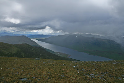
Loch Ericht from Beinn Udlamain
Sgairneach Mhor from Beinn Udlamain
A' Mharconaich from Beinn Udlamain

Loads of the locals always laugh about the "all four seasons in one day", they couldn't be more right! Photos done and camera away it was straight over this summit on the path for the next one. Over this top it gets a bit craggy so the path veers to the right slightly but you can see the track that heads straight up to the plateau nearing the top of A' Mharconaich.

Loch Pattack from Beinn Udlamain
Spey Vally from A' Mharconaich
Sgairneach Mhor from A' Mharconaich

I sat here for 10 had a drink and a mars bar laying against the cairn there. All done there was one top left to do, I headed WNW and skirted around the top of the path there (593765) so not to lose too much height (which I would have had to inevitably regain). From here it was a straight push through the rocks for the top. Again I took time for a quick breather here before I headed down over the top of Geal Charn and got a view of Balsporran Cottages in the bottom. My legs were feeling a bit lead-like and my feet a touch concretey so I was descending at a milder rate then the rest of the day, nonetheless it had been awesome. At that point the phone went, "will you be ready shortly, we're about ready to go out for dinner" ha ha.

Loch Ericht from Geal Charn
It's a grassy/muddy slope all the way down then the very last part I rejoined the path I skirted round the top of on my way to the last summit. Over the railway line and I was sat on a boulder dreaming of a pint and beef of some description. All told the Scottish weather had been pretty kind it never really threw it down although I was surrounded by it pretty much all the time (I think the photos give a good impression of that). This hiking trail gives you the true feeling of being surrounded by a real wilderness which is unreal and reminds you why you're alive! It was sufficiently dry too that I got away with trainers rather than boots which makes it half the task and the pace is a world apart from when you're in boots. This is a great hiking trail too as you actually start from a fair altitude and it gives you great views once you hit the tops - highly recommended!
Balsporran Cottages


View Drumochter Hills Walk in a larger map
The contents of this page are all under copyright, should you wish to use any of this material please contact me.

Monday, 28 April 2014

Another slant on how to prevent blisters

With the Trailtrekker just around the corner (I now cannot believe I have committed to doing this again with in looming) and the training in full flight jaunting across the Yorkshire Dales and the Lake District bagging Wainwrights the prevalence of blisters is back with me so I've been again on the hunt for ways as to how to prevent blisters. I came across this video by Cotswold Outdoors;


I recall (how could I ever forget) how much pain the blisters threw at me, the chafing was manageable and the legs could have limped another 10 miles potentially but the blisters, oh the blisters were agonising. Everything to prevent the pesky blighters will be done...

Saturday, 7 December 2013

Walking with children

As I've just had a baby, well my wife did, my thoughts have turned to the practicality of walking with children (more specifically babies) pretty swiftly.

Seemingly they can only be carried in a baby carrier when they are around six months old or when they can hold their head up so we've got a few months to wait yet.

I reckon the key to this is comfort, obviously, as there is going to wind up with a fair amount of weight in there and for me to trudge any distance it's got to be a decent fit.

My brother bought one recently and was going to hit the hiking trail with the children for exercise but it didn't really happen. So he is kindly going to lend me his, although I'm not sure exactly what it is yet. It doesn't matter what it is I suppose so long as it's comfy for me and the baby. Then some flat walking, probably continuing along the Leeds Country Way as it's conveniently so close to home. Can't wait to get back outside.

Sunday, 15 September 2013

The search for pants...

That's in the American sense of the word pants - like trousers. I've had two pairs of Craghoppers Kiwi convertible trousers which have been worn to death (well I've attempted to but against all odds they've survived - they've been indestructible). They have stood the test of time so have proved that they are great value for money in that regard. After a recent spell of Munro Bagging however I was a bit frustrated in the drag against my legs when they got wet, one time through inclement weather (driving rain) and the other from sweat (nice). So now I am on the hunt for some trousers that don't suffer the same fate when they get moist and glide, rather than stick! I expect these wont come at the same bargain basement price as the Craghoppers Kiwi trousers but that's a price I'm prepared to pay (never has a phrase been so suitable).

Monday, 12 August 2013

A review of the Oxfam Trailtrekker - part 3

Now on painkillers we left for Conistone. I was in absolute agony here the blister I'd just treated on my right heel was killing me and my boot was rubbing on my left ankle. My stomach was still playing silly devils and my knee was giving me grief. I figured that we had about 7 hours to go if all went well, then it would all be over. The only saving grace that I didn't have to concern myself with chafing.

The light was just coming back here but it was still absolutely freezing, even with all the layers on with mittens and hat I couldn't get warm and we were some way into this section before I finally shed a layer.

It was also on this section of the hiking trail where questions were asked about the feasibility of completing. I'd stopped for a second and when I caught up with the other two guys they divulged that they thought they didn't have sufficient in the tank for another 30k's, I advised I'd come too far to sack it so I was going to plough on - likely with another team for safety reasons. One of the guys accepted the challenge and said he was with me. Dave was looking greener and greener by the minute. Not long later there was a tent giving warm punch laid on by Oxfam Trailtrekker, there was a steward here and a girl who was retiring. Dave took the opportunity and gracefully bowed out. Gutting that one of the blokes you've come so far with and has endured so much with you isn't able to continue with you. He was completely shot and had absolutely nothing left in him, he was hallucinating and didn't have the energy to keep his head upright any more. He later admitted he thought it was down to the fact he'd not eaten enough. We gave him a hug and left him in capable hands.

We headed through Kettlewell and on to Conistone. Our support team met us again, we weren't there long. We'd sacked off food now and were relying on dextro tablets, Kendal mint cake, lucozade sport and nurofen. I figured that we wouldn't have time to digest the food for it to work, plus I was so bored of eating. We just troughed sugar and high/fast energy stuffs to drive us on.

We were now only 21.5kms from home. I thought this wasn't far, I would normally not even be feeling any fatigue on this but after 80kms its a bit of a different matter. The climb out of Conistone was not an easy one either, well not at this stage in the game. Now every step was excruciating. I'd not changed my socks at the last stop thinking I could endure 20kms from here, after all it wasn't far, what an error. My feet felt massively bruised on the soles and the blisters were biting badly, the failure in my quest to prevent blisters was overwhelming. It was now a case of one foot in front of the other, I kept saying "inching ever closer" repeatedly to myself. This was fast becoming the most painful thing I'd ever done in my life. At the top of here the path leads you over moorland which was mud that had dried to be like uneven concrete which again isn't great for the soles of your feet. About halfway over the moorland though there is a section of about 100 metres of road. There was an ice cream man here giving all the Trailtrekker participants an ice cream, a great touch.

On the next section we were talking to some guys, I divulged the pain I was going through, they suggested I change my shoes, I told them I'd gone light and didn't have any, so they suggested socks, again - I'd gone light and didn't have any, one of the guys offered me a pair or his. My team mate had a pair which he let me use, this eased the pain and onwards we went. It was a nice gesture of the other chap though underlining the feeling of camaraderie that runs through all participants of the event. Before long we were onto the stretch into Hetton and the temperature was starting to soar as the sun was high in the sky.

It was uneven underfoot and was sore, I think the softest of marshmallows would have been met with a wince at this stage. The road into Hetton was like a Roman road and was as straight as a dye for as far as the eye can see, which wasn't great for morale, I found the best way to deal with it was to look at the floor as I trudged on.

At the end of this straight we turned right into Hetton and walked to the church where the water stop had been set up for us. I was running out of steam at 90 miles an hour now but this was the time to dig deep and find the resolve to get to the end, it was no distance now (comparatively) to get to the finish line.

The Oxfam Trailtrekker crew were amazing here though, they were all very chatty about nothing in particular trying to keep us all buoyant. As soon as we arrived they told us to sit down and take a load off our feet and asked us what we wanted. I asked for a coffee and a juice which were in my hands in no time, shortly followed by a tray of biscuits for us to help ourselves to. We were also asked if we had any bottles they could fill for us, I asked for my camelbak to be half filled as I didn't want to carry the extra weight. One of the support crew asked how many were left in our team and on discovering there were only 2 he told us to join another team in case one of us passed out en route to the finish line. Which we duly did (join another team, not pass out) but with refreshed fire in our bellies and the line so close we were now fuelling solely on Kendal mint cake and dextro's and were really pushing for the finish.

Coming out of Hetton we headed left through a stile and the hiking trail took us alongside the stream. Essentially we followed the stream all the way to Flasby where we went through a gate and took a left over the stream. The road went up the hill and passed a farm before the hill continued through a countryside field. We were now continuously chewing our way through Kendal mint cake and dextro's. The feet were still pretty painful but were numbed by the adrenaline of now being able to smell the finish line. The route continued through High Wood then into what was Crag Wood although this has now been felled.

Before long the uphill is done and its downhill all the way into Skipton although it still is about 3 miles or so to go. This slog whilst painful was endurable as the finishing line was lunging towards us. Before long we were heading over the overpass with Skipton in sight. We were marshaled through a housing estate and into Aireville Park. This truly was the last straight of was had been the toughest undertaking of my life both physically and mentally.

My wife and my teammates girlfriend appeared in the distance, cheering us along, what a welcome sight they were. My shoulders could take no more and I offloaded my pack onto my wife, it was as though my shoulder muscles were continuously being stabbed with red hot needles. A few yards later the hiking trail arrived at the school gates and were met by marshals and supporters. Our numbers were radioed it to someone, I had no idea who. As we rounded the corner onto the field the finish line came into sight and the cheers from the supporters became louder. We crossed the finish line, completing the Oxfam Trailtrekker, 100km (63.5 miles) in around 27 hours and 50 minutes mostly in pain of some description in some part of my body or other. What an achievement... We sat and had a couple of beers which never touched the sides. I said at the time never again but the following week we all met up for beers for a birthday and with the blisters healing and the sense of achievement sinking in we thought that knowing what we know now we could slaughter that time and those that didn't do it wanted to complete it. So that said - bring on the Oxfam Trailtrekker 2014.
 
Copyright (c) 2010 Roam the Hills. Design by WPThemes Expert
Themes By Buy My Themes And Cheap Conveyancing.