Pages

Monday 18 January 2010

The Lakeland 3000's

I was in the pub the other night having a few fine beverages when I had a banter with Si, a Dark chum of mine, with whom I completed the Yorkshire 3 Peaks hiking trail year. This was no walk in the park but we managed to complete the 25 miles in just over 10 hours (some of the blokes did do it in under - one ran the last 8 miles from the top of Ingleborough which was a feat in itself - he was keen for a pint though in fairness). Just after we completed the Yorkshire 3 Peaks hiking trail it was muted that we undertake something a bit more challenging this year (as if that wasn't enough) so he has come up with a new challenge which I haven't quite come across before and thinking about it for very good reason. We did originally discuss doing the National 3 Peaks however on further inspection it appears that this would be too easy (cough cough splutter wretch). Since our chat on Friday I've searched high and low for a walking resource that details or explains this "8 3000 Peaks" route (or similar) to no avail however I am pretty sure there must be some headcase out there that has bitten off this mouthfull and successfully chewed it. Undoubtedly there will countless more folk out there that will have had a good gnaw and ended up spitting out the mangled mess!

The challenge is to take in the 8 highest peaks in England (all over 3000 feet) within 24 hours. All of these are in the Lake District and are as follows;

Skiddaw northern fells 3054
Lower Man (Hellvelyn) eastern fells 3035
Hellvelyn eastern fells 3117
Broad Crag southern fells 3064
Ill Crag southern fells 3068
Scafell Pike southern fells 3209
Symond’s Knott southern fells 3146
Scafell southern fells 3164

This is gonna be a huge undertaking, being around 42 miles in length and around 10,500 vertical feet it is going to be torture but it is being done for a great cause - Dreams Come True.

The plan is to break the colossal hiking trail into 3 roughly even parts and head to the Lake District to walk each leg in preparation. The aim of these acclimatisation walks is two fold, firstly and the most obvious is for physical training - 42 miles is a fair slog and without training, especially in the hills, it will for sure be impossible. Secondly we need to know the route we are to take. If we head in the wrong direction for even as little as 15 mins on the day we will have obviously have to backtrack that 15 mins, saving time is essential and we can't afford that delay, nor can we afford the wasted energy in covering that ground.

I wondered what this years challenge was going to be. Not any more.........

Below is a map of the route we're going to take;


View 8 peaks route in a larger map
Tuesday 12 January 2010

Lake District: Great Gable, Green Gable, Base Brown

Date: December 2009
Those there: Me, Growler, Wellsy, Nimrod
Hills Climbed: Green Gable, Great Gable, Base Brown
Map: Explorer OL4
Distance: 5 miles

We yomped up to the Lake District for Growlers birthday to get away for the weekend and bag some of the Wainwrights. After having seen Great Gable a year or so earlier from the top of Scafell Pike it launched itself towards the top of our list of hiking trails to conquor.

We stayed in Seathwaite camping barn (235121) which is not the nicest of camping barns that I've stayed in and is probably the reason why it is not listed with the official camping barns website but in fairness it has a cooker and kettle etc. which is pretty handy and saves you taking your own. The toilet is a bit elusive though and is a public loo around the back of the barn which would have been good to know in advance as it's not too easy to locate in the pitch black. It is very handy however for larger groups as it accommodates in the region of around 20 people no problem.

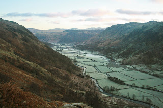
We woke up at about 7am on Saturday morning so that we could get a real early start. At this time of year I feel it's important to get use of as much daylight as you can as we probably only have around 8 hours from dawn 'til dusk. We had our customary fry up and were out of the barn for about 8:15. It wasn't fully light at this point but was doing it's utmost to brighten up. We headed west and took the path which runs through one of the barns on the farm (signed campsite) and headed up the hiking trail to left hand side of the stream. It was still below freezing at this point but the view up the valley was stunning, the whole of the valley bottom was fairytale white with the frost and looked unreal.

Borrowdale - Lake DistrictNot wanting to stop for too long because of the cold we pressed up the hill until we came to the wall and gate at the top of the first stretch (228122). We had a bit of a breather here whilst some of the guys seized the opportunity to take some snaps. By now the sun had started to come out and unbelievably there was not a cloud in the sky. This was amazing considering the fact that it was only a month since the Lake District had suffered torrential rain and widespread flooding which was still evident in certain areas.

At this point we walked in the shadow of Base Brown and hugged that side of the valley heading for the saddle between Base Brown and Green Gable (222222). The sub zero temperatures were great in some respects that all the standing water was ice and made for much easier going then losing your feet in a bog every time you put them down.

Haystacks and Buttermere from Green GableAs the incline increased the hiking trail started to zig-zag to the ridge. At the top we took a right and headed for the summit of Green Gable. Here we experienced an amazing panorama of Haystacks which is a behemoth of a mass with Buttermere just in the background. This was a view to behold! The sun was really pounding up here but as we were quite exposed the wind was also pretty fierce and kept the temperature below zero. Needless to say we didn't stop here long before we descended the back of Green Gable, through the aptly named windy gap and up Great Gable. This was a bit rocky but isn't too tough and you soon make good progress. There is a memorial at the top of Great Gable for those members of the Fell Rock Climbing Club who sadly fought and lost their lives in the first world war, as we were here in December there was a sea of poppies here obviously from a memorial service that would have been held a month prior.

If you head past the memorial you get to take in the view of Wasdale Head and Wastwater which is truly incredible with the land flattening out beyond the valley as it runs away to the sea. This is the point where the highest mountain in the UK (Scafell Pike) meets the deepest lake in the UK (Wastwater). We took a pew here out of the wind and soaked up the view. Because we had set off so early in the morning there was only one other lady on the summit which means we pretty much had the view to ourselves and it's quite pleasant once you get out of the wind.

Wastwater and Wasdale Head - Lake District
We had a spot of lunch here, and fed and watered we began back along the hiking trail. As we descended Great Gable we passed a number of people who were obviously heading for the top, it was at this point that we smiled that we had managed to get to the top and have the views to ourselves, what a benefit it was to get up and out so early to try (and succeed) in avoiding the crowds.

Borrowdale from Base Brown - Lake DistrictWe then headed over Green Gable and headed for the summit of Base Brown in order that we could get the view of Borrowdale in its full glory. Once at the top we did get an amazing view and again took a few minutes to savour the hip flask and soak up the sights. The valley bottom was still white as the temperature clearly hadn't got much over freezing throughout the day. It had however been bright blue skies which you can only ever wish for. From here and looking at the map it didn't really look as though there was a hiking trail down and that we may have to backtrack to the path however we saw some folk heading over the spot where the Hanging Stone is marked on the map. We headed off in that direction and saw that it was a steep descent but wasn't a problem.We did pass around and underneath the Hanging Stone then came back to the wall that we had come through earlier on in the day.

We took the hiking trail along side the higher side of the wall to the gate that we had come through earlier. It was then a simple case of following the stream that we had walked beside that morning back to the barn in Stonethwaite.

We got changed and headed to the Riverside Bar in the Scafell Hotel for a few well earned beers (which tend to go straight to the cranium after a day in the fresh air) and a steak, all in all most welcome indeed.

The walk home from the pub naturally took us a bit longer, well actually a lot longer and I would say it's not actually fair to call it a walk home - stagger is more the word.

Something didn't agree with Wellsy either, I reckon it could have been his 7th pint as I'm pretty sure the 11th was fine! Boy did he know about it though.

A great weekend in the hills was had by all. We found out at the end of the weekend that we'd had the first dry weekend since September, someone was for sure looking down on us that weekend.

Geoffrey also found out, much to his disgust, that he'd ripped his bag on the yomp on the Saturday. However upon closer inspection we realised that it wasn't a rip but a cunning rodent had knawed through it to get to the choccy biscuits. Lesson reiterated, never leave food on the floor. Oops


View Walk up Great Gable in a larger map
 
Copyright (c) 2010 Roam the Hills. Design by WPThemes Expert
Themes By Buy My Themes And Cheap Conveyancing.