Those there: Me on my Jack Jones
Hills Climbed: Sgairneach Mhor, Beinn Udlamain, A' Mharconaich and Geal-Charn
Map: Explorer 393
Distance: about 11 miles (ascent 1150m)
I was staying in Scotland again at this time and got a bit of spare time so jibbed out for a walk in those there hills (more appropriately mountains really). I got a lift to the start of this hiking trail as I wanted to finish at a different point to where I started to avoid the road miles. I was staying not far from here so it was no great shakes for someone to run me out.
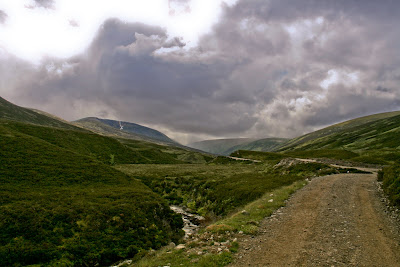
I got dropped off on the A9 south of Dalwhinnie in the Highlands (at 633751) and walked under the bridge heading into the hills along the track up Coire Dhomain next to the stream. Not long later I passed and greeted 2 guys who were just on their way back to the road, as it turned out they were the only people I saw all arvo which is always a pleasure. The track meanders up the Coire in the shadow of Sgairneach Mhor alongside the stream all the way. It had been quite a nice day up until this point but seemingly it looked like it could turn, anything can happen in the Highlands weather wise so I wasn't overly holding out a mountain of hope.


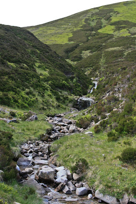
When the path comes to a bit of an abrupt end (593742) I took a turn south and trudged straight uphill next to the stream (it was more of a trickle really). As expected the sky turned a darker shade of black and whilst I donned my waterproof jacket waiting for the deluge to hit a rainbow appeared what seemed to be about 50 yards away (always hard to tell as they're pretty deceptive and I never have found that pot of gold either way though it was pretty close) but no rain followed. The sun continued to shine on the righteous, needless to say I was thoroughly in the shade.

Anyway I carried on trudging for the plateau which I reached eventually and the first thing that hit me with the view to the west was the overwhelming sight of Highland wilderness, truly incredible! So after shouting WOW a couple of times, which was to be heard by myself alone, I made the very short stroll to the top of Sgairneach Mhor. From here you get a great view up and down the Spey Valley on a good day needless to say my vista had a pretty moody feel, still no rain yet though.


Customarily I absorbed the view into the memory bank and then kicked off along the hiking trail to Beinn Udlamain which you can visibly see straight across the other side of the valley. For ease sake though I followed the plateau down to the saddle (578727) at a semi jog and then followed the path to the summit. It was about this point that the rain caught up with me and gave me a good dowse, causing a bit of frustration as I was sweltering and could have done with shedding a layer (not until the rain packed in though).
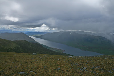
This is a pretty straight run and over your shoulder you start to get a pretty impressive view of Loch Ericht. Although the weather was a bit crappy. At the top i sat down and took a couple of photos looking down the loch with a fairly oppressive and moody atmosphere. Literally only a couple of minutes later though, bizarrely the cloud seemed to disperse and the rain went from a light spitting to non existent, perfect demonstration of how the weather can behave up here.


Loads of the locals always laugh about the "all four seasons in one day", they couldn't be more right! Photos done and camera away it was straight over this summit on the path for the next one. Over this top it gets a bit craggy so the path veers to the right slightly but you can see the track that heads straight up to the plateau nearing the top of A' Mharconaich.


I sat here for 10 had a drink and a mars bar laying against the cairn there. All done there was one top left to do, I headed WNW and skirted around the top of the path there (593765) so not to lose too much height (which I would have had to inevitably regain). From here it was a straight push through the rocks for the top. Again I took time for a quick breather here before I headed down over the top of Geal Charn and got a view of Balsporran Cottages in the bottom. My legs were feeling a bit lead-like and my feet a touch concretey so I was descending at a milder rate then the rest of the day, nonetheless it had been awesome. At that point the phone went, "will you be ready shortly, we're about ready to go out for dinner" ha ha.

It's a grassy/muddy slope all the way down then the very last part I rejoined the path I skirted round the top of on my way to the last summit. Over the railway line and I was sat on a boulder dreaming of a pint and beef of some description. All told the Scottish weather had been pretty kind it never really threw it down although I was surrounded by it pretty much all the time (I think the photos give a good impression of that). This hiking trail gives you the true feeling of being surrounded by a real wilderness which is unreal and reminds you why you're alive! It was sufficiently dry too that I got away with trainers rather than boots which makes it half the task and the pace is a world apart from when you're in boots. This is a great hiking trail too as you actually start from a fair altitude and it gives you great views once you hit the tops - highly recommended!

View Drumochter Hills Walk in a larger map
The contents of this page are all under copyright, should you wish to use any of this material please contact me.


2 comments:
Wow! Nice pics, what kind of camera do you use, or are you just that super a shooter?!
It's a Canon 400D, can be a bit of a pain lugging an SLR up the mountain but you can for sure see the difference in the quality of the shots.
Post a Comment