Pages

Saturday, 6 April 2013

The Leeds Country Way Hiking Trail


The Leeds Country Way Map

So I had my anterior cruciate ligament reconstructed in November and have been undergoing physiotherapy since then. It's been pretty intense but ultimately you get out what you put in and the more of a slog I put in now the better the results will be in the long run. As all physiotherapists will tell you the actual operation is only half the battle, the rest is down to the patient and the exercise. 

Living on the outskirts of Leeds I decided to have a look at an ordnance survey map of Leeds to see what there was locally instead of driving the hour or so to the Yorkshire Dales, the North Yorkshire Moors, the Lake District or the Peak District. It would probably be easier on my joints too on the flat rather then up hill and down dale. Whilst it would unquestionably be preferred to walk in Yorkshire Dales, the North Yorkshire Moors, the Lake District or the Peak District the 2 - 3 hour round trip makes it a bit impractical. So looking at the map I stumbled (visually, not literally) on the Leeds Country Way which is a 62 mile route around the outskirts of the city. 

So as part of my physiotherapy I started along the Leeds Country Way from Woodlesford, heading towards Methley with not the best results. I started off along the Leeds Liverpool canal and whilst it was pleasant, it was a touch less than inspiring. It's fairly well marked and this section was all very flat, naturally as it was along the canal side for the main part. I think we did about 6 miles as a circular route. So to surmise, this part of the Leeds Country Way was fairly uninspiring and sadly was too close to suburbia to avoid litter. That said I'll persevere with it as the rest may turn out to be quite different. 

Thursday, 4 April 2013

New Boots vs New Trainers


Merrell Mid Moab Boots
 
In winter conditions I wouldn't consider wearing anything but my Meindl Bernina (review here) clodhoppers. They offer awesome support and are toasty warm.

There is a monstrous compromise though and that is the weight! As a direct result the fatigue sets in far far quicker than in trainers. I swore by my North Face Hedeghogs! They were awesome and have only recently crumbled, they have split, which is devastating. So I'm now on the lookout for a replacement.

I thought about going the same and going in for another round with the North Face Hedgehog but am also considering alternatives. Why not got for a lightweight boot? So that's where I think I'm headed.

I've dug about and the Merrell Mid Moab boot seems to come up as being pretty highly regarded and well received by most that have got them. They're goretex and have vibram soles so should suffice nicely. I'll keep the North Face Hedgehogs in mind as a lighter weight flat option but only need one pair for now and will se how the Merrell Mid Moab boot goes.

Whilst my Meindl Bernina will always have their place I think a lightweight shoe with the support of a boot will kill numerous birds with just the one stone. A difficulty I may come up against is the widened of my feet. When I bought my Meindl Bernina I did so because they were the only boots I could find that would house my wide feet. We'll see how the Merrell Mid Moab boots go on that front.

Wednesday, 23 January 2013

Wainwright Bagging Around Grasmere and Great Langdale

We were staying in The Daffodil Hotel in Grasmere in the Lake District so we looked for a walk that was reasonably close to Grasmere and wasn't too much of a trug so that we could be back at a reasonable time to take advantage and wallow in the spa.

We decided to do some of the Wainwrights out of Great Langdale as there looked to be a decent walk that took in 5 Wainwrights within a pretty short yomp. We kicked off from The New Dungeon Ghyll Hotel and headed straight up the road and through the gate.


From here we headed left, instead of straight on over the bridge, and through the break in the wall. We walked up the hiking trail in the valley with the stream on our right. 

A Waterfall Near Great Langdale

Before long we crossed over the bridge now with the stream on our left hand side. Stopping briefly to take in the waterfall we carried on up the valley until we arrived at Stickle Tarn. 

Wainwright Bagging


Great Langdale
View into Great Langdale

From here it was a short-ish hop, skip and a jump to the summit of the first Wainwright, Pavey Ark. From the top of Pavey Ark there are some really awesome views down Great Langdale to Lake Windermere. 

 The View From Pavey Ark 
View from Pavey Ark down Great Langdale to Lake Windermere

 View from Pavey Ark of Great Langdale and Lake Windermere 


The next Wainwright was Thunacar Knott Which was surprisingly only a matter of around 250 metres from the summit of Pavey Ark. Sadly the views from Thunacar Knott were pretty much none existent as the clouds fired over the plateau that sits between the five tops of Pavey Ark, Thunacar Knott, Pike of Stickle, Harrison Stickle and Loft Crag. Again it was only a few hundred metres jaunt over to the base of Harrison Stickle from Thunacar Knott. The climb was pretty straightforward to the top of Harrison Stickle. We didn't stop up here long as the wind was howling at this point. But we did get pretty incredible views across the plateau and over to the Pike of Stickle which emerges out of nowhere. 
 
View from Harrison Stickle to Pike of Stickle and Loft Crag

From the top of Harrison Stickle it doesn't look so far away but this is slightly deceptive. As you descend a chasm appears that you've naturally got to descend before climbing up the far side. You've got to attack the Pike of Stickle from the far side and whichever way you have a shot at it it's a scramble, there is no real easy way. It isn’t that much of a last push though and the views are awesome from up here!

View from Pike of Stickle to Harrison Stickle and Loft Crag

So that was 4 boxed off, just Loft Crag and we'd done the Wainwrights we'd set out to do. This is pretty much on the hiking trail home and is only a marginal ascent. Again the views down Great Langdale and through to Lake Windermere are pretty awesome. You can also see the Great Langdale campsite from here where they've got some kind of posh camping options for those that are averse to tenting it.

Great Langdale


Great Langdale View

Knowing that we had to descend via the valley to the village of Great Langdale we kind of set off walking along the wrong route intending to descend adjacent to the stream in Dungeon Gill. This was never going to be possible as it’s sheer from this side of the valley however from the map it looks doable on the other side of the valley albeit on a minor path.

On the descent as we were getting close to the bottom we came around a corner to get the full impact of Dungeon Gill Force which is hugely impressive. Stopping to take some photos of the waterfall and talk to the sheep we carried on to the stream at the bottom where we joined the hiking trail we'd started on earlier in the day. Back through the gap in the wall and a short walk down into Great Langdale to finish the walk off. Then back to the Daffodil Hotel in Grasmere for a pint and a dip in the pool very pleasant, a great walk.

Dungeon Force Waterfall

Tuesday, 13 December 2011

A Photography Course around Bolton Abbey

Looking to get the best of my snaps whilst out in the hills I went on a photography course recently around Bolton Abbey in an attempt to try to get my photos to resemble what I see in the flesh whilst I'm out there in the open.


Wednesday, 7 December 2011

A trek through Glen Etive to Loch Etive

We recently spent an incredible weekend up in Glen Etive near Glencoe. We were blessed with awesome weather and managed to get two reasonable yomps under our belts in the three days we were there (the other was spent roaming the loaclity taking some snaps).

Glen Etive reflection
A Lochan reflection in Glen Etive
 
November could be expected to be a bit hit and miss with regards the weather but we couldn't have had it better, it was foul as I drove up Glen Etive but by the time the rest of the blokes arrived about an hour or so later the clouds had parted exposing all the peaks around the valley.

Glen Etive Landscape
The landscape of Glen Etive
 
We left the car park in the morning with the view of getting yomping cross country down Glen Etive to the Loch to take some time lapse footage some time late in the day. We took maps and the trusty Satmap Active 10 but really just sidled down Glen Etive with no real route in mind. A couple of days earlier we'd been bagging Munros so a few of us were keener for some lower level stuff. We started by hugging the River Etive which was pretty impressive and picturesque not coming across another soul. We had to take a right when we hit a tributary that would have given us seriously wet feet, ankles, knees and waist and head towards the road. This actually ended up taking us across a small footbridge but we still had to hit the road eventually.

Flowing Etive
 A flowing River Etive
River Etive Flowing
River Etive

We continued up here until we came to another road which led to a bridge across the river we'd just followed. We wanted to try to get up the hillside on the eastern side of Loch Etive as we thought we'd get a better view. This proved to be far tougher then we'd anticipated but I've not laughed so hard in some time.

Golden View down Glen Etive
A Golden View
Once over this bridge we were guided around a property where it started getting really boggy and was tough tough going. This didn't get any easier and before long we had a river to cross, which was no great shakes and we decided to take a spot of lunch here in the middle of the tributary.

Dry River Bed
Crossing the dry river bed
 
Once over the river the bog turned to marshland and was just wet up to about the ankle. We persevered and headed back down to the river we'd crossed as there was a dry bed which would at least have furnished us with some better footing. It didn't as it turned out and only served up larger doses of humour. We decided to get off the river bed and back onto land - into a patch or gorse where we couldn't see the way through or way out. this led to dead end after dead end and cries of help were heard all around - these were met with cries of hysteria.

A marshy Glen Etive
A look over the marshes of Glen Etive to Loch Etive
 
Once reunited on the far side we decided unanimously that the ascent up the hillside was a painful idea and that we'd be better off catching the shot from the edge of Loch Etive. This therefore meant that we had to cross the river again. There was no bridge however which was going to prove to be a touch tough as there was no clear way it could be crossed without a bit of an inconvenience unless we walked back up to the bridge which no one was really keen on. One of the boys spotted a wide part of the River Etive which he thought looked relatively shallow and went for it.

Crossing Rive Etive
Crossing the River

It was only when he had crossed it that he realised that he'd only crossed the river to the same side that he'd ultimately started from - he was confident his boots had held out though and his feet were still dry. In the end half of us were down to our pants and the others risked it with gaiters on. It was cold but brief and relatively painless.

River reflection
A river reflection

We were not long before we were back on the road and heading for Loch Etive. We timed it pretty much bang on and got the sun disappearing over the horizon. At the same time a canoeist appeared at the far end of the Loch, not sure where he'd been but he was met by a seal proving that there was access from the sea to here albeit being a touch of a hike.
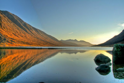
Loch Etive
Loch Etive

Once we'd got the footage we required we kicked off on the lengthy hike back up the road. It was too dark now to go cross country again - that would have been painful. What seemed like a fair age later we were back at the car park. Not the most conventional of days walks but totally varied terrain and what seemed like an awesome adventure in an incredible part of the world, it was totally stunning.


View Glen Etive Walk in a larger map
 
Copyright (c) 2010 Roam the Hills. Design by WPThemes Expert
Themes By Buy My Themes And Cheap Conveyancing.